File:User-Vordur Steel-Hammer-Map of High Rock.jpg
The UESPWiki – Your source for The Elder Scrolls since 1995

Size of this preview: 670 × 599 pixels. Other resolutions: 858 × 768 pixels | 1,900 × 1,700 pixels.
Original file (1,900 × 1,700 pixels, file size: 1.04 MB, MIME type: image/jpeg)
Summary[edit]
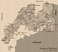
A detailed map of High Rock. Still missing these elusive names of Wrothar subzones.
Licensing[edit]
| This image is licensed under the Creative Commons Attribution-ShareAlike License 2.5. You are free to share and make derivative works of the file under the conditions that you appropriately attribute it, and that you distribute it only under a license identical to this one. |
File history
Click on a date/time to view the file as it appeared at that time.
| Date/Time | Thumbnail | Dimensions | User | Comment | |
|---|---|---|---|---|---|
| current | 11:56, 7 December 2015 |  | 1,900 × 1,700 (1.04 MB) | Vordur Steel-Hammer (talk | contribs) | whoops |
| 11:53, 7 December 2015 |  | 1,900 × 1,700 (627 KB) | Vordur Steel-Hammer (talk | contribs) | minor consistency correction | |
| 15:04, 18 November 2015 |  | 1,900 × 1,700 (1.04 MB) | Vordur Steel-Hammer (talk | contribs) | A detailed map of High Rock. Still missing these elusive names of Wrothar subzones. Category:User Images |
- You cannot overwrite this file.
File usage
The following page links to this file: